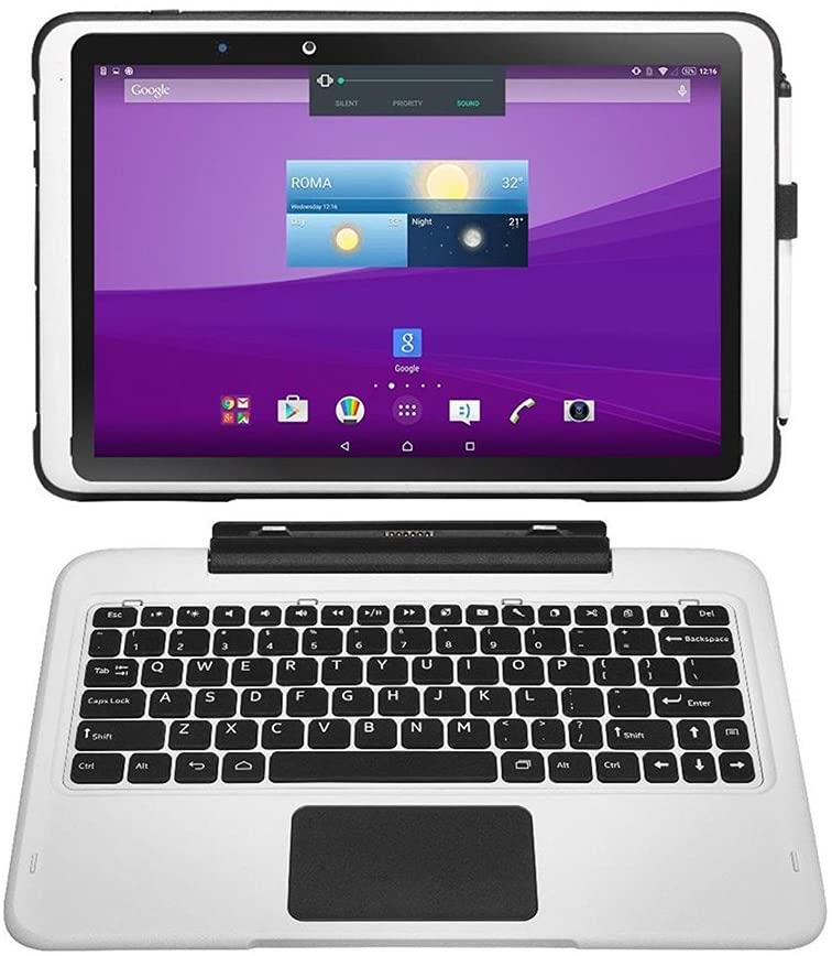
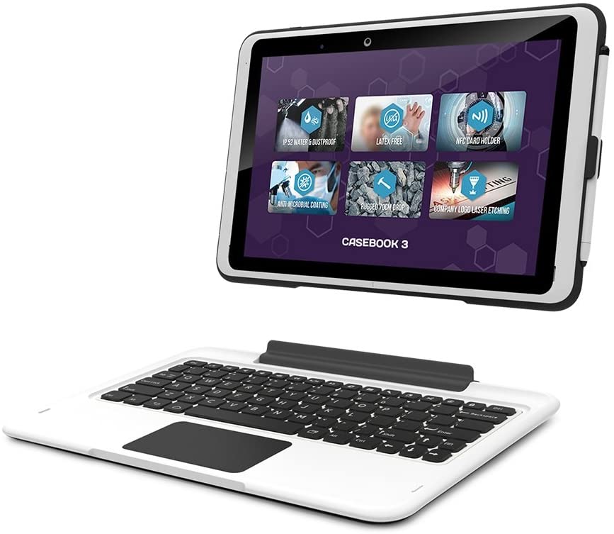
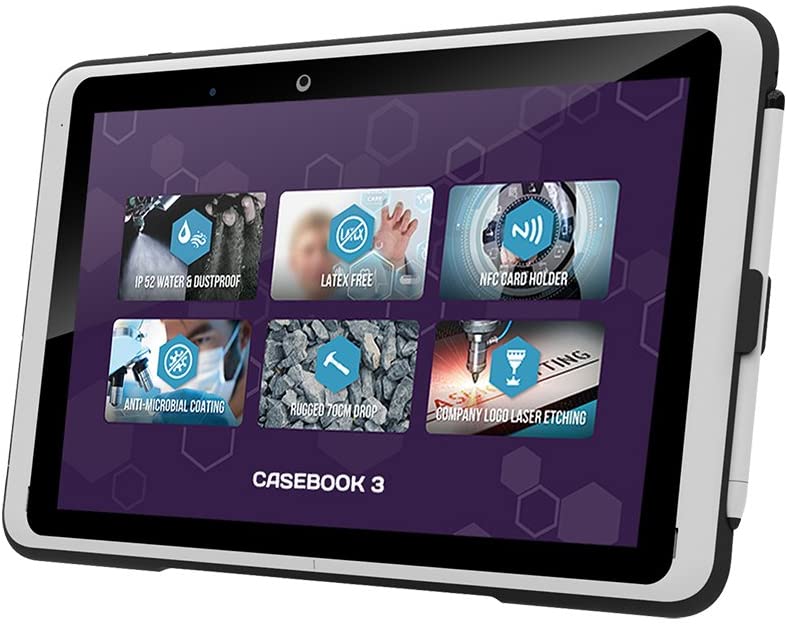
- The casebook 3 is light and easily transportable and can be used as a full laptop or tablet
- The casebook 3 has a bright and easily readable touch screen with stylus or multi-touch finger input
- The casebook 3 is IP52 rated and is protected against dust and water ingress
- The device is rugged without any extra bumpers or protection which can harbor germs and dust
- The casebook 3 also comes with the additional feature of a smart card holder
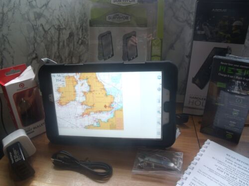
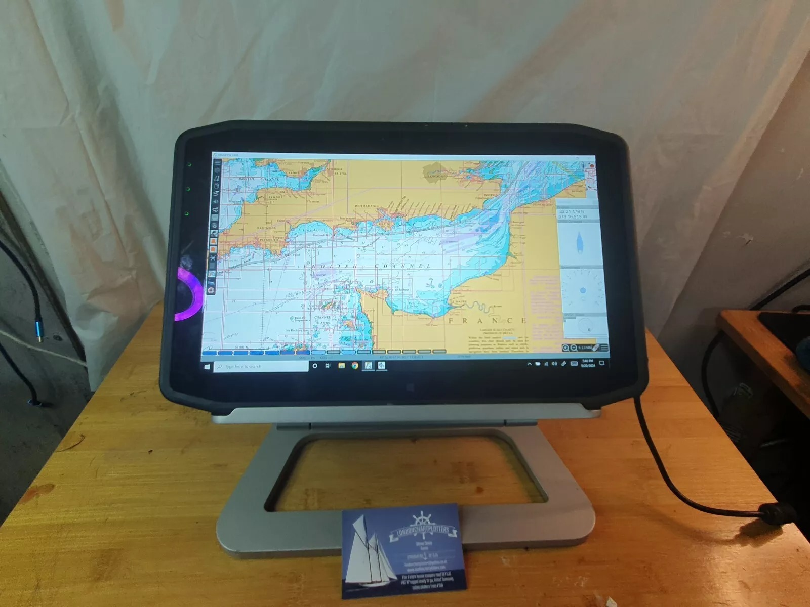
NON GOOGLE PLAY O.E.M. LATEST MARINE NAVIGATOR LICENCED APP INSTALLED WITH THE CHARTS.SOFWARE MANUAL IS INCORPORATED IN HELP WHEN YOU OPEN MARINE NAVIGATOR.A SHORT DEMO VIDEO IS PUBLISHED BY US ON YOU TUBE....SEARCH LONDONCHARTPLOTTERS.
Marine Navigator is an app developed by Mr Ronald Koenig and available in the Google Play Store. It is a fully functional chartplotter app, that uses standard free raster charts (KAP files) available for certain areas, like the USA and Brazil. The app can also use encrypted chartsets making available licensed copyright charts for the UK and other areas. Marine Navigator comes with no pre-installed charts, and costs about £6.50 in the Google Play Store
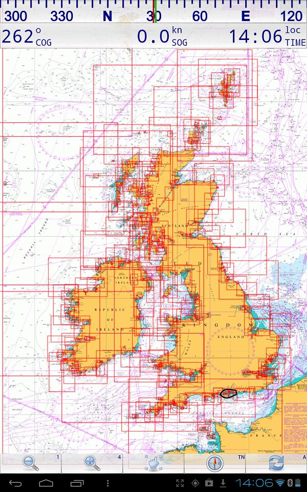
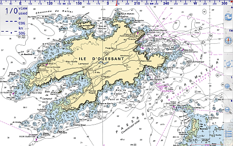
The above screenshot shows the chart outlines in "Marine Navigator"
"Thanks for the great service. The charts on the Android are so superior to the reproductions on the Raymarine - my main navigator with MFD = that I always use the actual raster chart display on the Android for inshore navigation" MC
Why "Marine Navigator" ?
Because we've found it to be so easy to actually use in real seagoing situations. The designer Ronald Koenig, is responsive and continues to update his app all the time. It's versatile.. In addition to our encrypted charts, it can also use standard BSB2/3 charts you may already have. For instance Antares charts for W. Scotland. This app can even calculate routes using Great Circle (for ocean sailors) or Rhumb lines.
"Marine Navigator is an offline navigator using raster navigational charts (RNC's) to plot your position in real time. This way you can navigate with true copies of official paper charts on your mobile device. This full version of the Marine Navigator provides besides the functionality of the lite version the following enhanced functions:
* automatic chart switching depending on current position and zoom level
* scrolling through all charts available for the current location by "press and hold" zoom buttons
* display of number of available charts for current location in the zoom buttons
* display of outlines of installed charts in active chart
* chart rotation (True North, True Course, Compass Heading, original chart orientation)
* tracks, way points, routes
* follow route automatically
* intuitive route editor
* gpx import and export of waypoints and routes
* gpx export of tracks
* recording of tracks in active and standby mode
* length of recorded tracks only limited by the capacity of the external storage (SDCARD)
* compass (magnetic north, true north)
* different dashboard layouts (basic data, detailed route data, detailed GPS data including graphical status info)
* Man Over Board (MOB) functions"
Our favourite feature so far: Being able to point the tablet at the bows, "Compass Up", and having the "True Course Line" switched on. This show as a dotted line stretching ahead the CMG by the boat. So "at a glance" the navigator can see how much the current is having an effect on the boat at that instant. (Or leeway for that matter).
The "Compass Up" feature also allows you to positively identify buoys or seamarks from a distance, by lining them up with the tablet/phone.
Note: Not ALL Android devices have a built in compass.
AIS screenshots
This example is using an underlying map, not a chart:
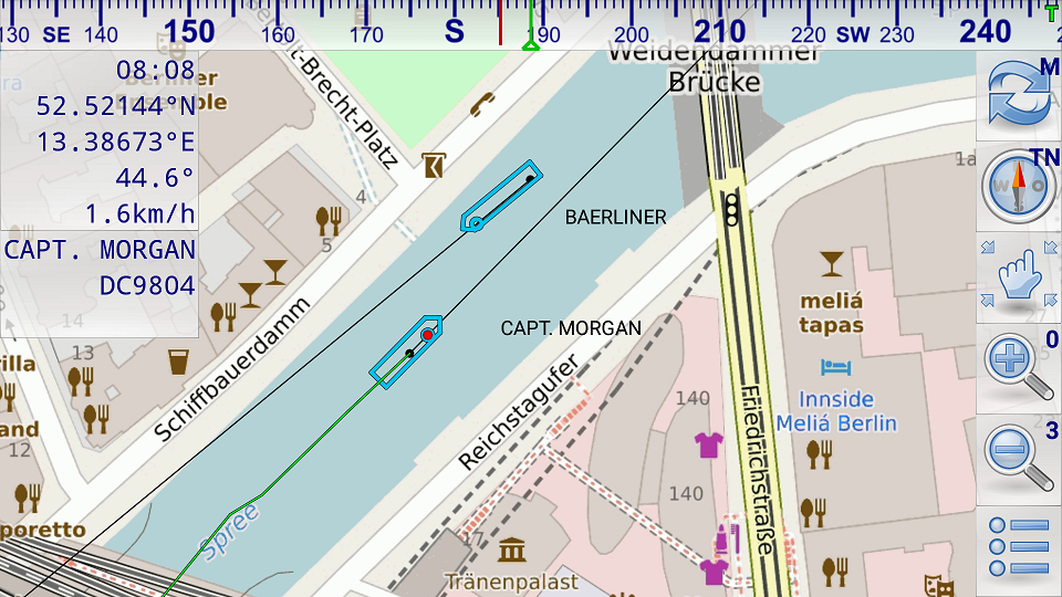 In this picture above both vessels have send position reports and static voyage related data (name of vessel, call sign, ...). The black dots show the last received position. The black lines show the predicted course. The position of the vessel is calculated based on the data of the last received position report (position, COG, SOG). The dimensions of the vessels are taken from the last received static voyage related data report. Capt. Morgan is selected therefore its detailed data are shown in the upper left corner of the screen and its track based on the previously received position reports is shown by a green trailing line. Capt. Morgan has not specified its destination. Therefore destination information is missing below the call sign.
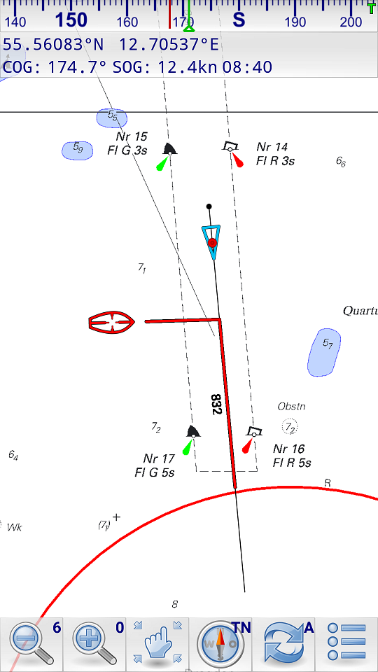
This picture above shows a collision alert. The red line on the own course line shows the passing distance when the other vessel crosses the own course line. The red line on the course line of the AIS target shows the passing distance when the own vessel crosses the course line of the AIS target. In the illustrated case the own vessel will cross 832m behind the AIS target. The AIS target (red cursor) is selected. It hasn't send any static voyage related data yet. Therefore only data of the position report is shown (position, SOG, COG).
A FEW FREE MARINE APPS INSTALLED F.O.C,,EG WEATHER/GRIB/ETC. SOME OF THESE REQUIRE A INTERNET CONNECTION.MARINE NAVIGATOR,THE NAV APP DOES NOT..
FREE 2022 UPDATE ON THE ALL CHARTS BY DOWNLOAD
IF IN 2023 YOU WANTED FRESH CHARTS IT WOULD BE 29.95 AT TODAYS PRICE FOR A FULL SET OF 2023,S WITH A FREE 2024 UPDATE.
THIS IS A FULL TURNKEY SET...YOU COULD OPEN THE PACK ON THE BOAT AND GO SAILING.
THIS DOES NOT NEED INTERNET/SIM/WIFI TO NAVIGATE..IT USES GPS AND GLONAS SATTELITES...FREE... TO GET YOURE POSITION...ACCURATE TO WITHIN A COUPLE OF METERS MAX.
IF IN 2023 YOU WANTED FRESH CHARTS IT WOULD BE 29.95 AT TODAYS PRICE FOR A FULL SET OF 2023,S WITH A FREE 2024 UPDATE.
THIS IS A FULL TURNKEY SET...YOU COULD OPEN THE PACK ON THE BOAT AND GO SAILING.
THIS DOES NOT NEED INTERNET/SIM/WIFI TO NAVIGATE..IT USES GPS AND GLONAS SATTELITES...FREE... TO GET YOURE POSITION...ACCURATE TO WITHIN A COUPLE OF METERS MAX.NO ANNUAL CHARGES..EVERYTHING PAID FPR AND UP AND RUNNING.
UNPACK THIS ON THE BOAT AND YOU WILL BE FINE!!!!!
| System Information | |
|---|---|
| Operating System | Android 6.0.1 |
| Model | TETRATAB CASEBOOK_3 |
| Motherboard | TF10EA2_Medical_1 |
| Memory | 1.86 GB |
| Brand | TETRATAB |
|---|---|
| Package Dimensions | 15 x 12 x 12 cm; 3 Kilograms |
| Manufacturer reference | TETRATAB-1TTC31A |
| Manufacturer | Tetratab |
| Series | Tetratab Casebook 3 Rugged 10.1" 2-in-1 Laptop / Tablet with Detachable Keyboard & Stylus, 4G LTE, Intel Quad Core, 2GB RAM, 64GB Storage, Android 6.0 - 1TTC3AWN-AND6 |
| Standing screen display size | 10.1 Inches |
| tanding screen display size | 10.1 Inches |
|---|---|
| Screen Resolution | 1280 x 800 |
| Processor Brand | Intel |
| Processor Type | None |
| Processor Speed | 1.44 GHz |
| Processor Count | 4 |
| RAM Size | 2 GB |
| Computer Memory Type | DDR SDRAM |
| Maximum Memory Supported | 256 GB |
| Hard Drive Size | 64 GB |
| Hard Drive Interface | Solid State |
| Hard Disk Rotational Speed | 1400 RPM |
| Graphics RAM Type | DDR2 SDRAM |
| Graphics Card Interface | AGP |